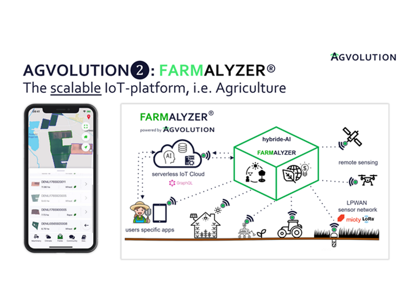
AGVOLUTION provides a revolutionary solution for assessing and adapting to regional environmental risks. Currently, AGVOLUTION IoT technologies can provide up to 1.5 million valuable data points per hectar of cultivated area on a daily basis.

AGVOLUTION Farmalyzer

Based on the CLIMAVI IoT Microclimate Sensor and other external, geo-spatial data sources, the FARMALYZER transparently presents economic costs arising on each agricultural field and suggests management strategies to increase the efficiency on a farm. Customers are provided with daily insights into environmental and ecosystem parameters, plant growth and other key-performance indicators. The FARMALYZER system is capable of documenting and balancing all processes of plant growth in agricultural and green spaces.

Following this strategy, the user obtains information about the resource efficacy, ecological impact, and cost based on a high spatial (10x10m) and temporal resolution.

Considering climate extremes and risks, our site-specific decision support can achieve economic and ecological optimizations of up to 40%.

Process variables like the irrigation demand, nitrogen fertilizer recommendations and satellite-derived indices can be accessed through existing management software and machinery.

AGVOLUTION also increases the amount of available data to up to 1.5 million points per hectare with the best-in-class IoT solution at the most affordable price.

Includes

  • IoT-Management platform – especially for weather relevant data and environmental monitoring

  • remote sensing products integrated in FARMALYZER such as high-resolution satellite data

  • Hybrid-AI decision support tool for plant growth e.g. irrigation, pesticide application, planting date/density and fertilization

  • yield and risk forecast for market research and insurance

  • soil database: estimated rooting depth, soil compaction, texture, and measured soil organic carbon

  • machine data processing (ISOBUS Standard (ISO 11783): georeferenced or telemetry; essential: total sum per field)

  • interfaces to common Farm-Management platforms

  • 2D and 3D visualization (coming soon)

Technical Key Facts

  • individual data output and -input; standard formats ESRI-Shape, GeoTIFF, GeoJSON, JPEG, PNG, ISO-XML, XML, JSON, TIFF, CSV, log, aft, ISO-XML

  • geo-spatial decision support e.g. irrigation in human and machine-readable outputs

  • worldwide-scalable applications & services with low latency

  • FARMALYZER App for iOS & Android

  • API for data fusion with geo- and time-referenced data (optional)

  • EASY to use API-Playground (optional)

  • flexible on-demand data formatting for map-visualization via API (optional)

Related Products

  • optional: CLIMAVI IoT sensor family or environmental monitoring in smart cities and rural areas

This mioty product is available

How can you acquire this mioty product?

Please contact the appropriate contact person or visit the provider's website.

Contact

Andreas Heckman

Phone: +49 551 27075944

E-Mail: contact@agvolution.com